


Google removed AI tool Nano Banana from Google Earth just a day after launch
Users managed to "bomb" skyscrapers in the USA, create nuclear facilities in Iran, and "destroy" the Eiffel Tower.

Google disabled the new image generation feature Nano Banana in Google Earth less than a day after its launch. The company explained this by stating that users began distributing generated images that "may violate platform rules" and promised to bring the tool back only after implementing "more robust protection mechanisms," writes the Telegram channel "Ostorozhno, novosti" (Caution, news).
The reason for the criticism was experiments by OSINT researchers and ordinary users. They discovered that text queries could be used to create photorealistic scenes directly based on Google Earth satellite images. Examples included a plane crashing into a skyscraper in Manhattan, a nuclear facility in Iran, refugee camps on the US-Mexico border, and a huge explosion crater in Los Angeles.
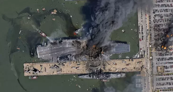
OSINT researcher Henk van Ess showed that he could "place" refugee camps near the Mexican border and "build" a nuclear facility in Iran in a few seconds by entering just a few text commands. According to him, the service hardly restricted such queries.
The GeoConfirmed community also voiced sharp criticism. They stated that Google Earth has long been one of the key tools for verifying information and geolocating, and the ability to generate realistic but fabricated satellite images could seriously complicate the fight against disinformation.
According to analysts, fact-checkers will now first have to ensure that they are not looking at a fake Google Earth image before analyzing the event itself. They also warned that malicious actors could create fake military facilities, change the purpose of buildings, or fabricate the aftermath of attacks, presenting such images as genuine.

Google emphasized that all generated images were marked as AI-created and were not displayed in the main version of Google Earth for other users. However, after a wave of criticism, the company decided to temporarily disable the function entirely.

On July 30, Google introduced the Nano Banana feature for the web version of Google Earth. It allowed users to generate images based on satellite imagery, aerial photos, and 3D terrain maps using text queries. The company suggested using it for visualizing historical events, creating infographics, architectural and development projects, construction planning, and other creative tasks. The tool was available to Google Earth users worldwide.

In the Mironets family, the mother and three sisters have already been convicted for political reasons. Now the husband of one of the sisters has been arrested


Comments
Акрамя пералічанага, людзі малявалі рускія танкі ў Кіеве, віселіцы для здраднікаў у Лондане і іншае.
2. ШІ і так умеюць дамалёўваць здымкі. Зараз проста прыбралі функцыю, якую зручна вызываць у самой праграме.
3. З улікам гэтага неабходнасць факт-чэкінгу не павялічылася. Як была, так і засталася.
4. Памыечныя сабчакоўскія «Осторожно, новості» (назва такая тут) самі не далі ніякіх першакрыніц, а тут у вас першакрыніца.
А што калі яны памыляюцца або далі фэйк? Хапае ж аўтарытэтных крыніц, ад BBC Verify, сам Google - увогуле шмат хто напісаў.
5. Сумна, што замест прапанаванага вывучэння гісторыі або планавання будучыні (ў тым ліку забудовы) людзі кінуліся правяраць тэхналогію вандалізмам.
Галоўная думка "як бы што знішчыць, захапіць, як напужаць".
Ад рэдактара. А можа б вы нам больш напісалі на гэтую тэму? Быў бы ўдзячны. Дашліце на [email protected] ці ў ТГ @nn_editor
[Зрэдагавана]