


US State Department Showed an AI-Drawn Map of Africa at an International Conference. It Was Surprising
At an international conference on HIV and AIDS in Rio de Janeiro on July 26, a US State Department employee showed a presentation with an erroneous map of Africa. It turned out that the map was created using artificial intelligence, Reuters reports .
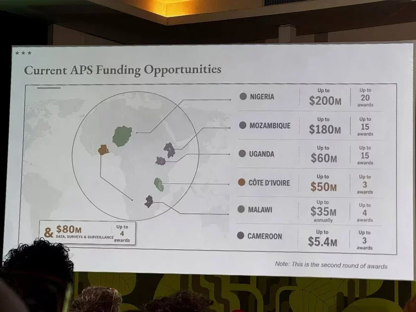
During the presentation, six African states were incorrectly labeled on the map — some of them appeared in the territories of other countries and even in completely different parts of the continent.
The most noticeable error was Nigeria. The country, where the US has several hundred military personnel, was shown on the map as a landlocked state located in the Sahara Desert. In reality, Nigeria is located in West Africa and has access to the Atlantic Ocean coast.
The incident occurred during the AIDS 2026 conference, which took place in Rio de Janeiro. As Reuters journalists discovered, the image had a watermark indicating the use of OpenAI tools for its creation.
The US State Department acknowledged responsibility for the error. According to the department, shortly before the event, one of the employees hastily made changes to the presentation. The report was presented by Jeff Graham — the principal US representative for health affairs and head of the US President's Emergency Plan for AIDS Relief (PEPFAR).
The State Department noted that, despite the erroneous map, the discussions and deliberations during the conference were meaningful and constructive.
Now reading


"Set up tents, lit bonfires." The Ministry of Internal Affairs confirmed the detention of 350 people near Rasony. They also found an argument: "Many were naked in front of minors"

"Set up tents, lit bonfires." The Ministry of Internal Affairs confirmed the detention of 350 people near Rasony. They also found an argument: "Many were naked in front of minors"
Sheiman Found to Have Another Possible Mistress and Son. A Secretary Without Higher Education Became the Owner of Luxury Homes and a Shopping Center in a Few Years


Comments
І такі выгляд нават не растлумачыш спробай намаляваць круглую Зямлю: вялікі акіян ад таго не сціснецца так.